The journey to reach this elusive destination helps travellers grasp the power and fragility of our changing planet.
The world is filled with wondrous places, but there are still many far-flung corners of the globe that few people ever get to see. In their forthoming book, Remote Experiences: Extraordinary Travels from North to South, photographer David De Vleeschauwer and travel journalist Debbie Pappyn journeyed to 12 of the world's most hidden, uncharted and remote territories relatively untouched by tourism. By going where the crowds don't, the duo is hoping to encourage others to travel slower and more purposefully, and to take better care of the planet we all share.
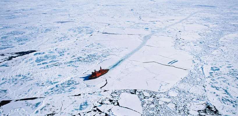
Owned by no one, claimed by many, the enigmatic North Pole is a constantly shifting sheet of ice in the middle of the Arctic Ocean. The world's largest and strongest nuclear-powered icebreaker, 50 Let Pobedy, sails every summer to 90° north with 100 passengers aboard, all eager to set foot on the geographical top of the globe. For most of them, this moment is much more than ticking off a list. It is all about the voyage.
When the ship cracks an ice sheet 3m thick on its way there, it sounds raw and without reservation. The name of the ship means "50 Years of Victory" in Russian, and refers to the 50th anniversary of the Soviet Union's triumph in World War Two. To commemorate its launch, the ship carried the Olympic flame to the North Pole in 2013 during the run-up to the Sochi Winter Olympics. Powered by a pair of 171-megawatt nuclear reactors and two 27.6 megawatt steam turbo generators, the almost 160m-long icebreaker can reach 21.4 knots – almost 40km per hour – and sail nonstop for almost six years without returning to land for refuelling. With nuclear reactors on board, fuel stops become almost a thing of the past.
The behemoth's primary mission is to carry super sized cargo ships through the frozen Northeast Passage in winter. During summer, the icebreaker transforms into an expedition ship for exploration and adventure, departing from its home port of Murmansk. From here the ship sails in the direction of the mythical Franz Josef Land, where only Russian ships are allowed to drop anchor.
There is a throwback quality to those who travel this far north, an eccentricity reminiscent of early explorers who were not deterred by extremes or afraid of challenging situations. After leaving Murmansk, it takes two days to reach the pack ice. This is the realm of the polar bear, where human visitors face a new set of rules. From here onwards, the frozen silence, the supernaturally white panoramas, and the murky gloom of the frigid ocean below seem endless. As 50 Years of Victory slices through the blank landscape, the thunderous groan of the ship's steady progress reverberates through its red-painted, reinforced hull. Passengers wrapped in thick layers of warm clothes stand on the bow, watching the ice split, snap and crack, followed by the blue of the Arctic Ocean surging through, as if gasping for breath.
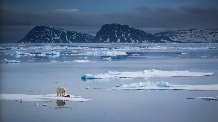
This is not an ordinary sea voyage aboard a fancy cruise ship. The route to the northernmost point on the planet, where the Earth's axis of rotation meets its surface, takes 11 laborious days, moving not much faster than 20km per hour when cracking through the ice. The presence of polar bears gives this voyage an extra dimension: in this frozen world, man is not king. Travellers take this trip not only to set foot atop the world but to be immersed in the raw beauty of the high Arctic.
There can be four seasons in one hour on top of the world (Credit: David De Vleeschauwer)
Gazing at vast expanses of sea ice is addictive and even soothing. The sun never sets in the Arctic summer and yet the light transforms constantly, reflecting off the pale white ice sheet. Sometimes the weather is cold, moody and dull, with a thick fog. Other days there is a velvety sheen to the light, flushed with pink or lavender tones. The frozen ocean is often delicately shrouded in a flowing palette of shades of white. It doesn't matter whether you are out on deck or gazing through a porthole in the warm belly of the ship to this ever-changing panorama. After a couple of days sailing, when the North Pole is finally reached, excitement ripples through the ship. Some passengers describe it as a feeling of recalibration, a new beginning.
FROM THE AUTHORS "The North Pole is an exceptionally rare and raw place where there is no concept of time and where every direction the traveller looks is south. In 30 years' time, it's likely that the geographical North Pole will be entirely ice free during the summer months and this unique feeling of otherworldliness could be lost forever."
On top of the world, it is time for a toast with ice-cold vodka. All passengers gather in a circle around the geographic North Pole and raise their glasses in cheer. The moment is almost triumphal. And then there is the infamous Polar Plunge, perhaps the most iconic swim anywhere in the world. This plunge, which is nothing more than a dip in the Arctic Ocean, is a once-in-a lifetime thrill. Daredevils warm up with mulled wine and more vodka, while the ship's crew sets up a barbecued lunch on the ice. In the few hours spent at the Pole, the sun is out, the wind picks up, the clouds arrive and it snows. There are four seasons in one hour on top of the world.
The North Pole is elusive; this place does not want to be caught. This is a very brief anchorage; remaining at the exact latitude 90° north lasts a minute or so. By the time the ship leaves, it has already drifted two nautical miles, almost 4km. The frozen ocean is in constant motion. On its way back south, the ship tries to retrace its tracks in the thick ice sheet.
By glimpsing this seldom seen landscape, the authors hope more travellers will be willing to protect it (Credit: Chase Dekker Wild-Life Images/Getty Images)
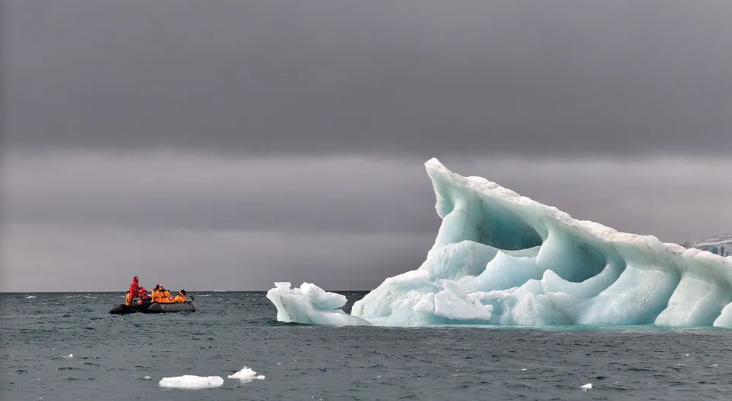
At Hooker Island, inflatable Zodiac boats take passengers along towering glaciers near Rubini Rock to witness spectacular bird cliffs where more than 70,000 kittiwakes, ivory gulls, little auks and guillemots nest. Helicopter rides allow bird's-eye views of the packed sea ice and the remote territory of Franz Josef Land. Passengers are invited to join these aerial jaunts to grasp the true vastness of this frozen desert. When the helicopter lifts, the massive, floating steel colossus that is the ship transforms into a tiny red speck in an ocean of bright, shimmering white, its tracks in the ice still visible like an artery filled with dark and cold Arctic Ocean. The helicopter swoops around the ship, letting the passengers grasp how endless and timeless – always bright or always dark – this landscape is.
Before this voyage, nobody would be able to realise that this panorama stretches all the way up there to the elusive North Pole. Now, after setting foot on that pole at 90° north, these travellers finally understand the vastness and magnitude of this thick blanket of white ice that stretches around the extreme and surreal top of our world.
A 70 mile strip of the A39 is more than just another thoroughfare. It's where generations of Cornish ingenuity blend with an influx of newcomers seeking a more rural life. Article continues below
Locals wouldn't say there's much romantic about the A39, a national highway that crosses south-west England. To most, it is a convenience at best, a site of accidents at worst so many accidents, in fact, that it has the unfortunate reputation as Cornwall's deadliest road, the likely result of everything from its often-narrow, winding nature to some tricky junctions.
But the A39 – particularly the section dubbed the "Atlantic Highway", a 70-mile strip that runs from Barnstaple, Devon, to Newquay, Cornwall is more than just another thoroughfare. It is one of the only arteries connecting an especially disconnected part of what is already a remote region.
That remoteness means two things. For one, it helps keep the area relatively wild. To be clear, north Cornwall is not a secret. The summer tide of tourists is felt everywhere, the area's carparks, beaches and pubs frothing over with visitors. But it's almost always possible to find a quiet cove or a cafe filled with locals. In the off season, even the most popular spots can be empty. And aside from Tintagel Castle of King Arthur fame, none of Cornwall's top 10 most-popular attractions sit here.
The remoteness, especially given the area's lack of train stations, also means that there are few good ways to explore the area.
I lived in this area with my family for two years. In that time, I fell in love with north Cornwall's ocean views, rolling farmland and dramatic cliffs, but with its lesser known attractions, too. Despite its remote and rural nature, north Cornwall is dotted with farm-(and sea)-to-table favourites, art galleries and unique museums devoted to everything from witchcraft to military history – the result of generations of Cornish ingenuity and artisanal heritage blended with an influx of newcomers seeking a more rural life, many of them even before Covid.
And so, when my family, lured by a job opportunity, chose to move out of England, I knew I had to explore this special region one last time. And that meant one thing: taking to the road, specifically the A39. This entailed navigating twists, turns and, more annoyingly, the odd overzealous car that rode my bumper if I dropped a mile or two below the speed limit. But it still made for an easier drive than many of the smaller, single track roads that link up to the A39. Then there were the benefits of using the main highway: its convenience but also – surprisingly – its moments of beauty.
Despite its name, the Atlantic Highway runs mostly through patchworked fields, bucolic villages and emerald green woodland, with occasional slices of sea seen from a distance. Technically, it starts seven miles inland of Newquay, home to Cornwall's only public airport.
This first section skirts some of the heart of Poldark country and the locations where some of the television series' lushest landscapes were filmed, including Park Head and Porthcothan. I headed here first. This is the Cornish landscape at its most dramatic and striking, the wildflower-covered cliffs plunging down to sandy coves, lapped by blue green water. After a hike along the South West Coast Path, I quickly worked up an appetite.
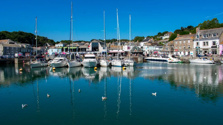
Luckily, one of England's prime "food capitals", Padstow, is just eight miles north off the A39. Once a pretty fishing village, today Padstow is better known for its restaurants. Rick Stein launched his culinary empire here, while Tripadvisor travellers recently rated Padstow as being the best place for Michelin-quality meals in the world.
So, it was only fair that I tried out the Michelin-starred Paul Ainsworth at No. 6, a restaurant known for its inventive plays on Cornish fare. While No. 6 pays homage to the area's fishing heritage, it doesn't overlook Cornwall's more land-locked offerings. Sometimes in one dish like my first course, a warmed, raw scallop in an acorn ham broth with kohlrabi tartare.
"It's a prerequisite that we have got incredible fish and shellfish," said chef Chris McClurg, the restaurant's chef de cuisine. "But what often goes overlooked is the quality and standard of the husbandry and farming in Cornwall."
One of their most beloved dishes, for example, is a main course called "all the pigeon" that uses every part of the bird in ingenious ways. A roast leg is wrapped in kataifi pastry (made of fine strands of shredded phyllo dough) and fried; the livers whipped into a parfait; the offal, mixed with dark chocolate, turned into a "pain au chocolat" and dipped into a "ketchup" made from Japanese sour plums. I'd never known a pigeon to be turned into such a balanced mix of sweet and savoury, crunch and tenderness.
But one of my favourite dishes was the simplest: a buttered scone. The scone itself was one thing. Then the server brought a glimmering yellow log. He hovered a knife through a candle flame, then glided it through the log with a motion that felt almost visceral. The butter tasted as good as it looked, creamy and lush, heightened with just the right amount of Cornish sea salt.
Despite its reputation, Padstow is far from the only place nearby to find good food. Back on the A39, I drove the 10 miles north to St Kew. I was still full from my Michelin-starred experience which is available as a set tasting menu only. But if I hadn't been, right off the highway is one of the area's finest farm shops, St Kew Farm Shop & Cafe, serving up a short menu of changing specials (think buttermilk-fried chicken with local slaw and jalapeno cornbread) and top-notch coffee, as well as one of my favourite grilled cheese sandwiches in the area, made with local sourdough and cheddar from Davidstow creamery just down the road. Or there's local favourite Aunt Avice's Pasty Shop, whose hot, fresh-baked Cornish pasties often sell out early in the day.
Turning through the quaint village of St Kew, I headed along one of the smaller B roads to the coast. Before long, the single-track road, high hedges on either side, opened up to the blue of the sea. Compared to its neighbours, Port Quin is a hidden gem. The only people here were a small group of kayakers bobbing out on the water. After popping coins in the car park's honesty box, I headed up the coastal path to walk off some of my lunch, ducking through thickets of blueberries beaded with rain.
Another couple of miles up the coastal road (or 3.5 miles up the path) is Port Isaac. Made especially famous by the long-running series Doc Martin, airing its final series this year, it is the quintessential Cornish coastal town: whitewashed cottages, small harbour, narrow lanes, and on either side, cow dotted hills with steep cliffs and views of the blue ocean. Like its neighbour Tintagel, it is one of north Cornwall's better-known destinations.
For something lesser-known, though, I prefer St Nectan's Glen, where a short hike takes you through an ancient woodland to a towering waterfall. Over time, visitors have strung the surrounding trees with prayer flags and ribbons, a practise often seen at sacred sites in Cornwall, and have built "faerie stacks" of stones. At the top of the glen perches an old hermitage, said to have been the residence of the 6th-Century saint Nectan himself. It's a spot that feels as mystical as any King Arthur castle.
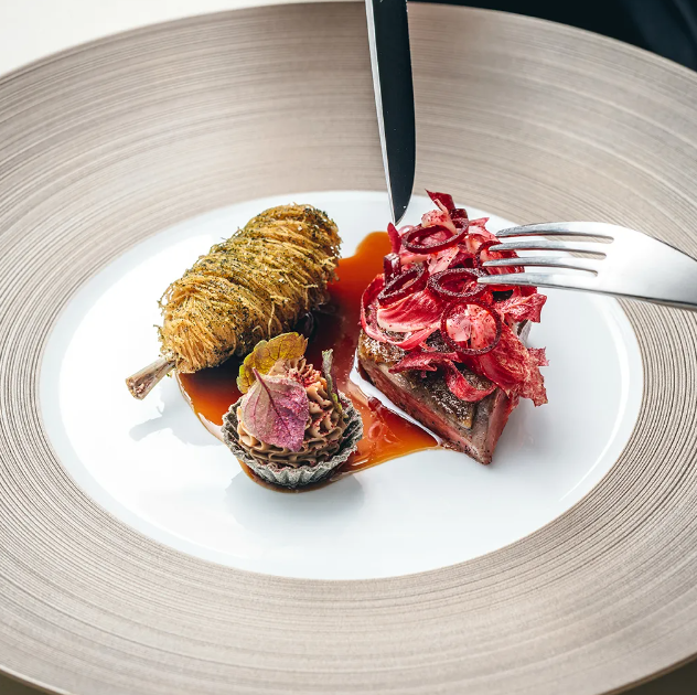
No. 6's "all the pigeon" dish uses every part of the bird in ingenious ways (Credit: Lateef Photography/Paul Ainsworth at No. 6)
For now, I was headed further north to Boscastle. One of Cornwall's more unusual towns, it's known for its quirky Museum of Witchcraft and Magic as well as the chefs, artisans and artists drawn both to its beauty and the opportunities afforded by tourism industry like new upstart The Rocket Store, which serves up dishes like wild sea bass sashimi with ginger and tarragon.
At the Old Forge Gallery, a centuries-old blacksmith's shop, I rummaged through prints and paintings depicting the area's striking scenery. The artist, Helen Setterington, moved here from Yorkshire 16 years ago. "We came so that I could study the sea and paint the rugged colourful and dramatic north coast," she said. "One day calm, the next day a storm of swirling waves. Just breath taking and very inspiring."
"One day calm, the next day a storm of swirling waves. Just breath-taking and very inspiring." Back on the A39, I stopped at a spot that revealed a different side of the area: the Cornwall at War Museum. Despite north Cornwall's remoteness, it's played a key role in past wars. During World War One, the coast was heavily defended from the German U boats thick in the water; in World War Two, the region hosted RAF bases, served as a launching point for the D-Day landings in Normandy and was the target numerous bombing raids. Even today, the area plays a role in the UK's national security thanks to GCHQ Bude, one of the UK government's main intelligence and security organisations. On a clear day, you can see the base's large, eerie white satellite dishes, perched on the coastline, from miles away.
Just off the highway, opposite Davidstow creamery, the museum sprawls across three acres of a decommissioned RAF airfield from WW2. It's the passion project and full-time job of local couple Steve and Sheila Perry, who gave me a whistle-stop tour.
"People spend hours just going around," Steve said, ushering me into a room crammed with naval artefacts. "And we see the same faces come back again and again." I could see why it would take a lifetime to take in everything he and Sheila had collected: medals, uniformed mannequins, hundreds of photographs and documents, even tanks and armoured vehicles.
Another 15 miles north on the A39 brings you to the turn-off for Bude one of the area's bigger "hubs" with almost 10,000 residents. The seaside town is known for a few things: its 19th-Century castle and heritage centre, its striking sea pool, its surfing (it is home to the very first surf life-saving club in Great Britain).
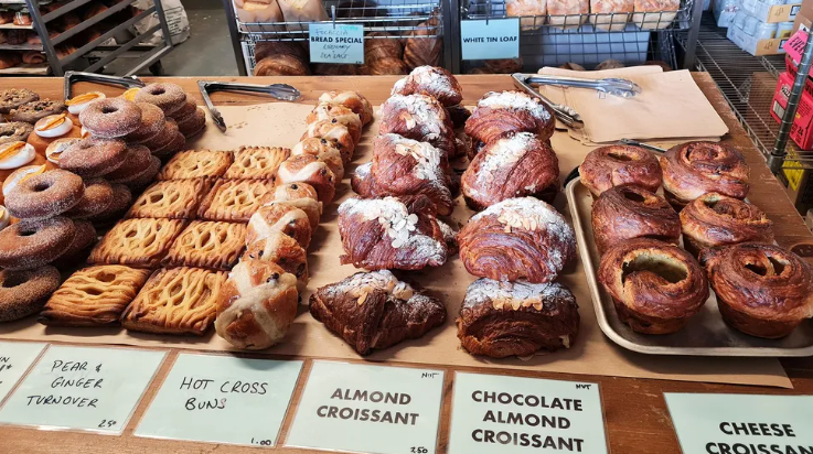
It's also known for one of the best cafes and bakeries in the region, Electric Bakery named after the former Western Power electric depot in which it's housed. Opened in 2019, despite never advertising, it quickly took off. "It grew quite organically because we were local first," said Christine Apiou, chef and one of the bakery's four directors.
Today, it's the kind of place where the staff seems to know everyone's names, it's impossible not to run into everyone you know on the weekend, and where customers happily queue for rotating specials like toffee apple buns or fried chicken bánh mì with pickles and lemongrass mayonnaise.
One aspect that sets Electric Bakery apart is that their mission isn't just to provide top notch coffee and baked goods, but to support locals as much as possible. That includes staff, none of whom are on seasonal or zero-hour contracts (which offer no guaranteed minimum hours). It also includes food producers. The cheese comes from a small dairy three miles up the road, the vegetables are mostly from a half-acre market garden in Bude, and they've even started growing their own wheat on the farm that co-director Alex Bluett owns – the flour behind the bakery's "three-mile loaf".
The result has been a local following so loyal, Bude real estate agencies even have started putting proximity to Electric Bakery as a "sell" for their properties.
Back on the A39, I drove through the medieval village of Stratton – my soon-to-be former home once known for its pivotal role in the English Civil War, but today a sleepy parish of Bude. The road curved and dipped through arcs of green trees, so close to the road that their branches embraced overhead, and took me past the Little Pig Farm Shop, which serves breakfast, lunch and brunch using products sourced from within 30 miles.
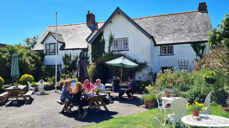
Pulling off the main road, I headed towards the coast to one of my favourite spots: the Rectory Farm Tearooms. Rectory Farm isn't a hotspot like Electric Bakery or The Rocket Store. It's an institution, opened in 1950 and since featured in magazines, on TV programmes and even as the set for films like the Guernsey Literary and Potato Peel Pie Society.
I reminded myself to heap jam on to my scone first Sitting in the tearoom's garden, I reminded myself to heap jam on to my scone first cross the border to Devon, less than two miles away, and I'd be obligated to put cream on first instead (the forgetful, beware!). Taking a bite, watching bees buzz around fat pots of flowers, listening to hikers trade tales from their time on the South West Coast Path, just a 10-minute walk away, I found myself, already, missing this part of the world: its scenery, its people, its history, its flavours, and yes, even its highway.
The Open Road is a celebration of the world's most remarkable highways and byways, and a reminder that some of the greatest travel adventures happen via wheels.
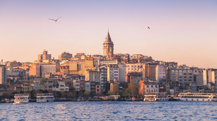
Found on every corner and renowned as one of Istanbul's favourite and oldest street foods, halka tatlisi has long been associated with the city's seedier side.
As I entered the grand arches of Istanbul's Misir Carsisi (Egyptian Bazaar) considered by many locals to be the city's greatest marketplace I was hit by a heady aroma of spice and kaleidoscope of colour. Moving with the current of busy shoppers sifting through a sea of produce, I spilled out on the market's backstreets where carts of stuffed mussels and barrels of stringed cheese sat alongside piles of pistachios, rose bud tea and bright pink olives. Transfixed by these treasures, I drifted, dream-like, until I spied the storied sweet I'd come in search of, beckoning beneath a pastry shop's glass.
Halka tatlisi ("ring dessert" in English) is one of Istanbul's favourite and oldest street foods. Found on every corner and said to help restore one's vigour after hours spent walking the busy streets, the circular dough that's deep-fried to a golden-brown and soaked in syrup has long been associated with the city's seedier side. And it's that connotation that gave rise to its local nickname of the "brothel dessert".
" [It's] known as a 'natural viagra'," said Turkish celebrity chef and restaurateur Somer Sivrioğlu, explaining its cheeky nickname to me.
Halka tatlisi was traditionally sold in Karakoy within the Beyoglu district on Istanbul's European side. The historical waterfront neighbourhood, formerly known as Galata, is positioned at the northern end of the Golden Horn – the main inlet of the Bosphorus Strait that has served as a shipping passage since Byzantine times.
Story continues below
Karakoy has been a port area since Byzantine times, and was once a hub for prostitution (Credit: Thipjang/Getty Images)
Originally a colony for Genoese merchants, Karakoy became home to various immigrants from the 13th Century onwards, including a large population of Sephardic Jews, when Ottoman Sultan Bayezid II invited them to settle here following their expulsion from Spain in 1492.
As a busy port, increasingly industrialised Karakoy also became a hub for prostitution. And in 1884, when a new regulation legalised Istanbul's first brothels, this red-light district originally intended for foreign visitors – continued to thrive for the next 137 years.
"Back when this was the old port, Anatolian tradesmen from rural areas and smaller cities would come to Karakoy for business and often visit the brothels," explained Istanbul tour guide Leyla Capaci. "Being cheap, delicious and high in sugar, the ring dessert became popular here because it's said that it gave men the energy they needed before – and after – visiting the working women."
Even though the brothels have closed, you still see a lot of halka tatlisi vendors hanging around this area Today, however, Karakoy looks very different. As I made my way from the viewing platform of Galata Tower, down through the cobbled backstreets, evidence of gentrification was all around. The last decade has seen warehouses converted into modern art galleries, while workshops have made way for hipster cafes, barbers and boutiques. But it's the recent closing of the remaining brothels on Zurafa Street that's the biggest indication of change their demolition currently making way for an arts and cultural centre as part of the Ministry of Culture and Tourism's Beyoglu Culture Road Project.
"Even though the brothels have closed, you still see a lot of halka tatlisi vendors hanging around this area," Capaci said.
Halka tatlisi is said to help restore one's vigour after hours spent walking the busy streets (Credit: Leyla Capaci)
I soon experienced this first hand. With seagulls swirling overhead, as I strolled over the Galata Bridge and passed fishermen casting their lines out over the glittering surface of the Bosphorus, it wasn't long before I met two men making and selling the city's darling of doughnut-like desserts. As I watched them squeeze batter traditionally made with semolina and plain flour – into hot oil through the star-shaped nozzle of a pastry syringe, I saw a familiar pattern emerging in the pan. Is the "ring dessert" simply a churro, I wondered?
"With its ridged edges, halka tatlisi is very similar looking to the churro, which is thought to have arrived with the expulsion of Spanish Jews as the result of the Alhambra Decree," Capaci told me. "The difference is that our version often called the 'Turkish churro' – has a circular shape and is derived from tulumba tatlisi."
Tulumba tatlisi ("pump dessert" in English) is a Turkish sweet that takes its name from the pump like apparatus or syringe used to distribute batter. Cut into small tubes before being fried and drenched in syrup, these "Ottoman doughnuts" are especially popular at celebrations such as weddings and during the month of Ramadan, giving a sugar hit to people who have fasted all day.
Although there seems to be a few theories as to halka tatlisi's exact path to Istanbul, I learned that halka tatlisi, tulumba tatlisi and churros all share a heritage in medieval Arabic cuisine, with the earliest known record of desserts of their kind stemming from a fritter called zalabiya mushabbak that appears in Kitab al-Tabikh (Book of Dishes) by Ibn Sayyar al Warraq. Considered the most comprehensive work of its kind, this 10th-Century Baghdadi cookbook offers a rare glimpse into medieval Islam's culinary culture and the role food played during the politics of its "Golden Era", when Baghdad was a centre for scientific and cultural learning, and religious and civil leaders gathered at opulent banquets.
"Tulumba is indeed the same stuff as halka tatlisi except the latter is identified by its shape," explained Iraqi-born food writer and food historian, Nawal Nasrallah, who translated the ancient cookbook into English for the first time as Annals of the Caliphs' Kitchens. She explained that many dishes migrated to Istanbul when Arab cooks were employed by the Ottoman sultans to work in their elite kitchens. "And while it's quite possible that Sephardic Jews could have influenced the churro look of this pastry with its ridged edges, we know that the fried fritters of Muslim Spain were influenced by Middle Eastern cuisine."
All these desserts share the same basic ingredients and method, where a designed instrument is used to pour batter into hot oil. "While zalabiya mushabbak was traditionally made by passing batter through a hole in a coconut shell into hot fat, halka tatlisi, tulumba and churros are formed using more modern utensils such as a kitchen syringe or piping bag to distribute the batter into the oil," Nasrallah said.
But what of these fried sweets' libidinous qualities, which gave rise to halka tatlisi being sold outside brothels? While the ingredient, rose – found in the rose water and honey syrup that historically perfumed zalabiya is a known aphrodisiac, Nasrallah said that sugary treats in themselves were believed to enhance sexual drive.
They believed that sweets in general were an aphrodisiac – boosting libido due to their hot and humid properties "People in medieval times followed the tenets of Galen's theory of the four humours, according to which they believed that sweets in general were an aphrodisiac boosting libido due to their hot and humid properties," she said. "And zalabiya mushabbak was a favourite, found on the tables of caliphs as well as the busy marketplaces."
Today, while no longer sold outside of brothels, halka tatlisi continues to be a beloved street food snack for Istanbulites, found in vendors' carts, pastry shops and now restaurants.
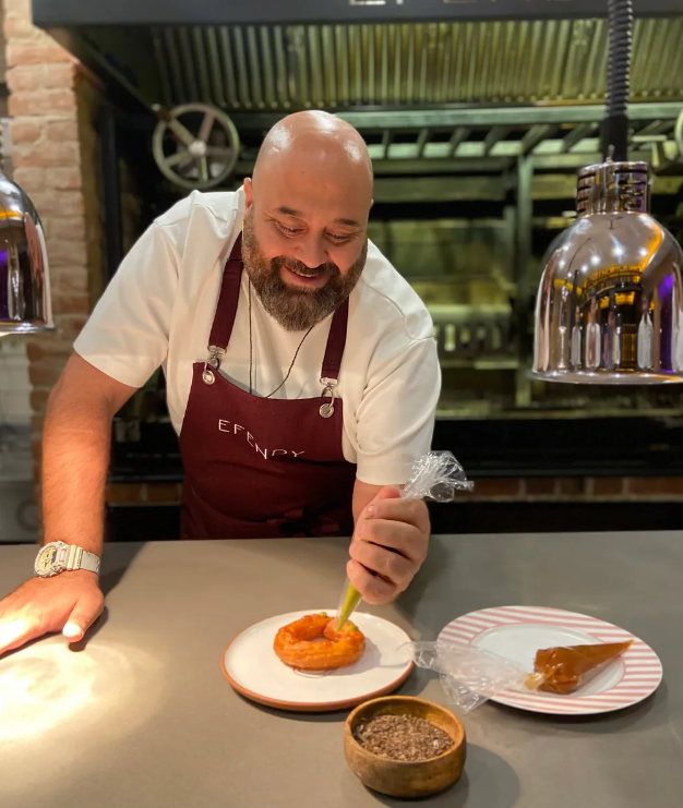
Sivrioğlu has plans to include an elevated, modern take of halka tatlisi on the dessert menu of his newly opened Istanbul restaurant, Efendy. "Our aim is to take this common street dessert and bring it to restaurant level," said Sivrioğlu, who is known for challenging preconceptions about Turkish food.
Also a judge on MasterChef Turkiye, Sivrioğlu gave contestants a halka tatlisi challenge a few years ago when he asked them to recreate the street-food favourite.
"The filming of the challenge was lots of fun because, although it seems like a simple dessert, halka tatlisi is actually quite difficult to get right. The oil's temperature has to be just right to create the crunch on the outside and the softness inside which proved terrible for the contestants, but great TV for us," he joked.
Sivrioğlu's new version, which uses pistachio flour sourced from Eastern Turkey in addition to the traditional semolina, comes drenched in sherbet water (a popular drink from the time of the Ottoman Empire made with fruit, sugar and water) and delicately dressed in dulche de leche. It's topped with crushed pistachio nuts, a sprinkle of sea salt from the seaside town of Ayvalik and a dollop of goat's milk ice cream.
In the affluent neighbourhood of Etiler, amid soft lighting, polished wine glasses and sophisticated guests, this elegant version of Istanbul's infamous "brothel dessert" was a far cry from the city's backstreets where I first came in search of the sweet. Instructed to eat while hot, I lifted a delicate morsel to my mouth. As the initial crunch gave way to creamy, velvety softness, an explosion of sweet delight ensued as sherbet water trickled down the back of my throat. Wickedly good, it was easy to see how this decadent dessert has endured through the centuries, giving pleasure to everyone from "sinners" to sultans.
For many, seeing the world's most famous shipwreck is a lifelong dream. And now, paying adventurers called "mission specialists" can get the chance to explore Titanic up close.
Four hundred miles from St Johns, Newfoundland, in the choppy waters of the North Atlantic Ocean, a large industrial vessel swayed from side to side. Onboard, Stockton Rush expressed a vision for the future:
"There will be a time when people will go to space for less cost and very regularly. I think the same thing is going to happen going under water."
Rush hopes that his company OceanGate will do for deep-sea exploration what innovators like Elon Musk, Richard Branson and Jeff Bezos are trying to do for space travel: allow anyone with enough money to venture to new worlds, even if they lack the specialist training.
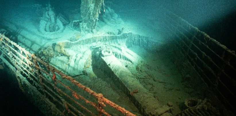
Rush's location in the North Atlantic is unremarkable at first glance. However, it is here that one of the most renowned and tragic events in history took place: 3,800m below the surface lies the wreck of the Titanic, which sank in April 1912 after striking an iceberg on its maiden voyage.
"There are three words in the English language which are known throughout the planet. That's Coca-Cola, God and Titanic."
For Rush, who is trying to make deep-sea exploration for the masses commercially viable, the site of the world's most famous shipwreck was a "must-do dive". He added, "I read an article that said there are three words in the English language which are known throughout the planet. That's Coca-Cola, God and Titanic."
But to make his Titanic dream a reality, Rush has had to create a new type of submersible made of lightweight materials that could take up to five people down from the ocean vessel to Titanic's depth. Many thought it couldn't be done.
Now though, Rush was at the site (after successfully reaching the wreck in the submersible last year) with a large mix of people, including the crew aboard the vessel, OceanGate staff, scientists and a small but crucial group of paying adventurers called "mission specialists" who each paid up to $250,000 (about £225,000) for a chance to see Titanic up close.
While there, they would also have the chance to help as citizen scientists, gathering pictures and video of the deep-sea biodiversity.
This particular dive included banker Renata Rojas, businessman Oisin Fanning and television professional Jaden Pan, plus oceanographer Steve Ross and submersible pilot Scott Griffith.
Jaden Pan is one of several "mission specialists" who get to see the Titanic up close (Credit: BBC's The Travel Show)
Rojas explained, "I'm not a millionaire. I've been saving money for a long, long time. I made a lot of sacrifices in my life to be able to get to Titanic. I don't have a car, I didn't get married yet, I don't have children. And all those decisions were because I wanted to go to Titanic."
"I'm not a millionaire. I've been saving money for a long, long time. I made a lot of sacrifices in my life to be able to get to Titanic."
For Ross, these dives offer a rare chance to study the deep ocean environment by taking water samples around the wreck site and making a record of the biodiversity with his camera. He said, "There is sort of a race to understand the deep sea, which is the largest environment in the oceans and the most poorly explored. Changes in the ocean have a huge impact over the whole globe."
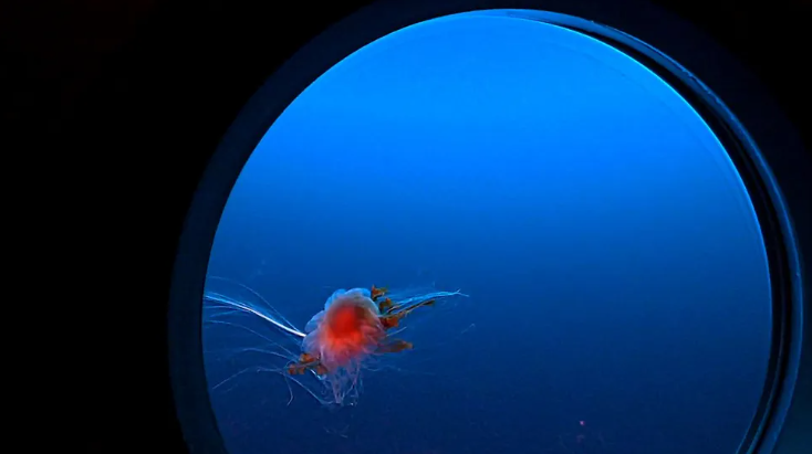
As the submersible descended for more than two hours to the bottom of the ocean with its passengers, onboard, Ross observed this biodiversity through the porthole window.
Dives to the Titanic wreck offer a rare chance to study the deep ocean environment (Credit: BBC's The Travel Show)
"On the way down, we saw mesopelagic animals [that are] involved in the largest migration on Earth. Every evening, this big community migrates to the surface, and each morning they migrate back down to 500 to 1,000m. A lot of those animals have bioluminescence, so you get flashes of light here and there."
When the submersible hit the ocean floor, it landed in the 15sq m debris field that surrounds Titanic's severed bow and stern.
"All five of us unofficially had this moment of silence," said Pan. "The first thing I see are pieces of coal. That's the moment that connected me to the humanness of the Titanic. The fact that people had shovelled this, had brought it onto the boat, and during the sinking, it just all spilled out."
Stockton Rush is trying to make deep-sea exploration for the masses commercially viable (Credit: BBC's The Travel Show)
From the other end of the submersible, Pan heard pilot Griffith say, "Oh no. We have a problem."
"When I'm thrusting forwards, one of the thrusters is thrusting backwards," Griffith explained. "Now all I can do is a 360." On the ocean vessel above, Rush considered remapping Griffith's controller. "It's not going to be easy", he told his fellow support crew.
"I thought, we're not going to make it!" Rojas said. "We're 300m from Titanic and all we can do is go in circles."
The solution which came to Rush was brilliantly simple: "Tell him to hold it the other way," he said. After establishing that turning left on the controller will move the submersible forwards, he concluded that turning the controller 90 degrees clockwise will make the submersible possible to go forward again.
An large ocean vessel takes people from St Johns, Newfoundland, to the Titanic site (Credit: BBC's The Travel Show)
assing colourful tiles, plates and a sink in the debris field, they soon reached their goal: the bow of the Titanic – iconic from when romance blossomed between the fictional Jack and Rose in the movie Titanic. Selfies taken, the remaining hours on the ocean floor were spent exploring the rest of the bow and more of the debris field before ascending to the surface.
While the analysis of the data they collected (from the video) will take some months to complete, the mission was instantly gratifying. Soon after emerging from the submersible back on the ocean vessel, Rojas wiped away a tear, saying "I needed to do it to feel complete. I feel now complete."
It was Independence Day in the Republic of North Macedonia, a landlocked Balkan country sharing borders with Greece, Albania, Bulgaria, Serbia and Kosovo. Along the northern shores of Lake Ohrid, bright yellow sunbeams of North Macedonian flags fluttered in the breeze that swept down from the Jablanica Mountains as bands played, rakia flowed, and beers were cracked open in celebration of independence from the Socialist Federal Republic of Yugoslavia in 1991.
However, it was coincidence, rather than by design, that my trip coincided with these annual festivities. Instead, I was heading to Vevčani, a fascinating village with its own little-known history of independence.
My bus left the lakeside revelry behind, and we turned into the foothills of the nation's mountainous western border with Albania. As we entered the village, there were few signs of a party atmosphere. The North Macedonian flag was flying outside the local government building, but it wasn't alone. Next to it, flew a flag I'd never seen before.
"That's the flag of the Republic of Vevčani," said Aleksandra Velkoska, a former tour guide who now works for the Vevčani municipality. "We don't celebrate independence today. Vevčani has its own independence to celebrate."
Story continues below
The Republic of Vevčani issues passports and currency as part of a bid to attract tourists (Credit: Richard Collett)
Despite having a population of just 2,400, Vevčani has attempted to declare independence three times from two different countries over the last five decades. In 1987, it first threatened to secede from Yugoslavia. Then, in 1991, the village proclaimed itself to be an independent republic just 11 days after the former Yugoslav Republic of Macedonia (as North Macedonia was previously named) had itself declared independence during the breakup of Yugoslavia. And in 2002, the libertarian spirit of the Republic of Vevčani was revived by locals as a tongue-in-cheek micronation in an unusual effort to draw tourists and poke fun at politics by flying a "national" flag, issuing passports and printing currency.
Vevčani's independent streak goes back centuries. Although it's located just a 20-minute drive from Struga, the largest town on Lake Ohrid's northern shore, the isolated and impenetrable terrain of the Jablanica Mountains ensures that the people of Vevčani have long been able to assert their autonomy.
Vevčani was nominally part of the Macedonian, Roman, Byzantine and Ottoman empires before falling under the jurisdiction of the Kingdom of Serbia, communist Yugoslavia and now North Macedonia. But after meeting me at the bus stop, Velkoska explained that Vevčani was never truly conquered.
"We are very traditional in Vevčani," Velkoska said, as she guided me up a hill to the Church of St Nicholas. From here, we looked out across the neighbouring villages, where minarets on the surrounding mountain slopes reflected the sunshine. "During the Ottoman era, for example, we kept our culture and our Orthodox religion, even though all of the surrounding villages are Muslim."
The village is nestled into the formidable terrain of the Jablanica Mountains (Credit: Richard Collett)
From the late 14th Century until 1912, the region came under the rule of the Ottoman Empire, which had its capital in what's now Istanbul. Around 33% of North Macedonia's population now identifies as Muslim, with the Ottoman legacy being particularly strong in the north-western region that borders Albania and Kosovo (both Muslim-majority countries). Vevčani is effectively an Orthodox Christian enclave in a Muslim-majority area.
The Church of St Nicholas dates to 1824, and beneath the hand-painted murals and frescoes inside, Velkoska introduced me to church caretaker Lambe Shurbanoski, who explained how Vevčani had considerable religious freedoms under the Ottoman Empire.
In the Ottoman era, you would normally enter a church by going down steps to symbolise that Christianity was below Islam
As Velkoska guided me further into the village, she explained how Vevčani's history of non-conformity under Ottoman rule inspired resistance during the communist era that followed World War Two, when the region became part of the Socialist Republic of Macedonia, one of the six republics within Yugoslavia.
"During the communist times, the government tried to stop our traditions," she said. "They didn't allow traditional weddings or baptisms, but our mothers and grandmothers still did these things in secret."
Locals also held onto a unique Slavic dialect found nowhere elsewhere in the country, and each January, the village hosts a 1,400-year-old carnival that draws thousands of visitors from across the Balkans to see revellers dressed up in elaborate costumes and masks.
At the centre of all the village's unique local customs is the Vevčani springs, which Velkoska took me to see next.
The Vevčani springs lie at the heart of the village's unique customs and celebrations (Credit: Richard Collett) The Vevčani springs lie at the heart of the village's unique customs and celebrations (Credit: Richard Collett)
"The springs are the most important part of our culture and history," she said, as we crossed over a small bridge and followed the riverbank towards the source of Vevčani's natural spring water. The source was hidden inside a darkened cave, but the entranceway was verdant and green where the spring water flowed into the riverbed. "Almost all celebrations and rites of passage are held here. It's why people were so annoyed when the Yugoslavian government tried to take our water away."
In May 1987, the people of Vevčani rose up in protest against the Yugoslavian government's plans to divert spring water to new villas being built by Lake Ohrid for the communist elite. In response, the village spent that summer building barricades, protesting and threatening to secede as the independent Republic of Vevčani.
The Vevčani Emergency, as it became known, lasted for three months. The government response was heavy handed, and special police armed with batons were sent in to end the uprising. Even so, the government backed down first, and the Vevčani Emergency became one of the first successful instances of mass resistance against the Yugoslavian government. Many of Vevčani's citizens continued protesting on and off for the next four years in Skopje and Belgrade in an ongoing attempt to hold the authorities accountable for arrests and injuries.
I learned more about the community's independent streak when we stopped for lunch at Restaurant Kutmicevica. "Do you have a passport?" asked restaurant owner Nasto Bogoeski as we sat down to eat. He wasn't talking about my British passport and was happy to see that I'd already purchased the red Republic of Vevčani version, complete with a dated entry stamp, from a souvenir stand near the springs.
Bogoeski told me that he was training to be a police officer in Skopje during the Vevčani Emergency. Despite this, he says he was there in spirit, and he's been involved in supporting the Republic of Vevčani ever since. When he retired from policing in the 2000s, he opened this restaurant, which serves local specialties like gjomleze (a type of slow-cooked pie), sheep's cheese and grilled vegetables served with a garlic sauce. All are cooked by Vevčani chefs, while Bogoeski regales tourists and travellers with stories of his beloved Republic.
Restaurant Kutmicevica serves up local specialties cooked by Vevčani chefs (Credit: Richard Collett) Restaurant Kutmicevica serves up local specialties cooked by Vevčani chefs (Credit: Richard Collett)
As he poured me a glass of rakia, Bogoeski explained what happened in Vevčani when Yugoslavia began to unravel in the 1990s.
"In 1991, there were referendums for independence all over Yugoslavia," he said. "In the same moment, the people from Vevčani decided they wanted a referendum for independence. We were politically motivated by everything that had happened during the Vevčani Emergency, and so we also wanted to be separate from Yugoslavia and from [North] Macedonia."
On 8 September 1991, the Socialist Republic of Macedonia declared independence from Yugoslavia and became the Former Yugoslav Republic of Macedonia. Not content with their new government, on 19 September 1991, the town almost unanimously declared itself an independent republic, with just 36 out of 2,000 locals voting against the motion.
The former Yugoslav Republic of Macedonia never recognised Vevčani's peaceful bid for independence, but given their government were also dealing with armed separatists in ethnically Albanian regions of the new country, they did eventually concede to demands for autonomy. In 1994, they allowed Vevčani to separate from the larger Struga Municipality and form their own autonomous municipality, which still exists today.
Bogoeski's daughter, Nikolina, added that in the early 2000s, the rebellious spirit of the village was revived and used to encourage tourism by marketing the Republic of Vevčani as a micronation.
People across the Balkans wanted to know more about the story behind our flag, passports and money "We made local passports and printed currency to advertise Vevčani," she said. "It worked, and people across the Balkans wanted to know more about the story behind our flag, passports and money. We have more plans to make a 'customs post' at the border to the village, where we can stamp the passports."
The village has a long history of rebellion and non-conformity (Credit: Richard Collett) The village has a long history of rebellion and non-conformity (Credit: Richard Collett)
Nikolina also said that, if necessary, the Republic of Vevčani could again become a serious entity in the future. "This is a very political village," she said. "Our village always comes first. If we held another referendum in the future, I think it would be possible for the village to be independent and stay successful."
After lunch, Velkoska took me for a sneak peek inside Vevčani's new museum, which is set to open later this year. Inside, political artworks depicted the Vevčani Emergency and the Republic of Vevčani, alongside a photographic exhibition devoted to Vevčani's centuries-old carnival. Interestingly, she said, the carnival is effectively a centuries-old satire, because satire is what Vevčani does best. Like its self-appointed micronation status, it's a way for Vevčani to mock the authorities, and many of the costumes and masks are politically charged, parodying the government or ridiculing recent political events.
Before I caught the bus back to Lake Ohrid, I asked Velkoska whether she thought the Republic of Vevčani was serious or satirical. "Vevčani still has its disagreements with the government," she said. "But we are too small to be independent. We would have a weak economy. It's a nice idea, but right now it's only for fun".